
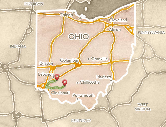
Cincinnati, Little Miami
 ABOUT THE ROUTE
Begin your exploration of southwest Ohio from downtown Cincinnati, where the art-deco masterpiece Netherland Hotel stands at the corner of Fifth and Race Streets. Its sumptuous 1930s Arcade and Palm Court, and the newly renovated Fountain Square across the street, occupy the position of the huge, elliptical earthwork that once dominated this high Ohio River terrace, as recorded on Dr. Daniel Drake’s 1815 map.
Indeed, Fountain Square is the symbolic heart of Cincinnati. This city grew and prospered in the early 1800s, on its large level terrace, above the confluence of three rivers. Two thousand years earlier, other people were here, and also built monuments on this spot. William Henry Harrison remarked that when he first saw this level plain, in 1791, “it was literally covered in low lines of embankments… The number and variety of figures in which these lines were drawn, was almost endless.”
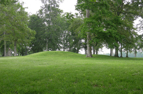
Mounds occupy prominent sites in several Cincinnati neighborhoods. The most dramatic is the Norwood Mound, about a twenty-five minute drive up US Route 22 (Gilbert Avenue then Montgomery Road). At about 6 miles, climb the hill and turn right (at the Mound Café) onto Indian Mound Avenue, where a small alley on the right between two houses encircles the tall, oval mound. The nearby water tank emphasizes the prominence of this spot, overlooking an ancient, pre-glacial course of the Ohio River.
The Cincinnati Museum Center, housed in the architecturally spectacular train station of 1931, presents excellent history and archaeology exhibits, including an interactive media program on all of the Little Miami Valley sites. Other area museums tell important stories of the history and culture of the area, especially The National Underground Railroad and Freedom Center, the Taft Museum and the Cincinnati Art Museum. The University of Cincinnati Campus (two miles north of downtown on the hill) displays its avant-garde, “earthworks-inspired” landscapes and recent buildings by world-famous architects.
West of the city in Shawnee Lookout Park is the well-preserved Miami Fort, a Hopewell era earthwork crowning a steep, isolated promontory overlooking the confluence of the Great Miami and Ohio Rivers [see Great Miami Valley itinerary].

Play video
Cincinnati’s earthworks
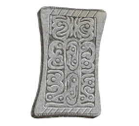
The Cincinnati Tablet was found in a large mound just west of Downtown; its abstract forms may suggest figures climbing the “tree of life”.
 MARIEMONT
East from downtown Cincinnati (follow US 50, Columbia Parkway), a series of picturesque suburbs conceal many important ancient sites. The valley of the Little Miami River once held the Hopewell era’s second-largest concentration of earthworks, including the spectacular Turner site.
Mariemont’s English ambience is complete with a Tudor Inn and a Gothic parish church. But street names like “Cachepit Way” and “Flintpoint Drive” hint at a much longer history, and out along Miami Bluff Drive, a long, ancient earthwork still stands among the trees. Cincinnati archaeologist Bob Genheimer:
At the edge of the bluff, they’re sitting right there, similar to works at Fort Ancient or Miami Fort where they’re at the edge of these really precipitous drops. We know that they’re real because Charles Metz, who’s normally considered the father of Cincinnati archaeology, noted them, recorded them in the 19th Century way before the village of Mariemont was ever developed.
The streets in Mariemont’s southern residential district all lead to Miami Bluff Drive (and the ancient earthwork), while at the end of the street a historical marker commemorates the “Madisonville Site” and the importance of this high terrace location in antiquity, and in the development of American archaeological knowledge.
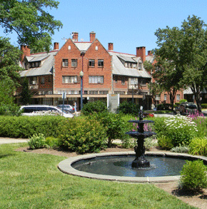
The beautiful village of Mariemont was carefully planned in the 1930s to resemble a picturesque English village.
 MILFORD AND NEWTOWN
A bit farther out along US 50 lies Milford, on the banks of the Little Miami on a spot once surrounded by Hopewell era geometric earthworks. Long before the growth of this eastern Cincinnati suburb, Squier and Davis described one of the Milford Works:
Diverging lines extend to the south-west, terminating in a maze of walls unlike any others which have yet fallen under notice. A portion of the parallels and the diverging lines just mentioned are much reduced, and when the crops are on the ground, are hardly traceable. From the hill an extensive prospect is afforded, bringing in view the sites of several large groups of works in the vicinity.
The “diverging lines” once topped the small hill above the historic Main Street. Faint ghosts of walls appear on old aerial photographs of a nearby cemetery. Yet if taken together with nearby Turner, these figures comprise one of the most extensive geometric complexes anywhere in the Ohio Valley region.
Just southeast of Milford lies another small village, Newtown, where along Round Bottom Road, two mounds lie inside Flagg Spring Cemetery (also called “Flagstone Cemetery” on Google maps, and formerly known as “Odd Fellows Cemetery”). Only one of the mounds is prominent and stands at the center. Nearby in the village, during excavations at the fire house, two spectacular shell gorgets were discovered, with detailed incised animal figures, created by a later culture that flourished here.
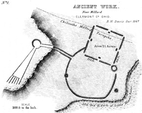
Squier and Davis’s 1848 drawing of the Milford Earthworks, with the unique “diverging lines” to the left.
 TURNER EARTHWORKS
Head out Round Bottom Road to the east from Newtown, to where a railroad overpass appears on the right. Beyond the rail line, contemplate the overgrown gravel quarries that were once the spectacular Turner Earthworks. From here came some of the Hopewell culture’s most spectacular artistry, including clay figurines, the mica serpent, and an effigy of a strange horned creature.
Here, two enclosures, one high, one low, were connected by a graded way. A long form trailed to the southwest. There were several mounds; but most unusual was a symmetrical cluster laced together by rings of stone. Doctor Charles Metz, of Madisonville, and Frederick Ward Putnam of Harvard University, investigated at Turner in the 1880s, and found some of the Hopewell Culture’s most spectacular artistry. Plowing of the earthworks had begun as early as 1825; and eventually it was all destroyed by a graveling operation.
Two mounds in this cluster contained remarkable secrets: In one, fires were lit in complex, clay-lined pits and chambers. Intense heat and smoke could rise through narrow flues. In an adjoining mound, a magnificent mica snake lay atop ritual deposits. Mica often cloaked such deposits; but here, as a serpent, it may have carried special meanings still known in the Woodland Indian tradition. Beneath the mica serpent were painted pottery statues, showing how the people dressed and arranged their hair.
Gravel pits near Round Bottom and Mt. Carmel Roads destroyed the Turner Earthworks.
 FOSTERS EARTHWORKS
Little is visible of the spectacular Milford-Newtown-Turner earthwork cluster today because of 19th century destruction. A little farther up river, and still intact (though on private land), is the decidedly strange hilltop enclosure at Fosters. A riverside gazebo (behind an unusual stone tavern building, beneath the high US 22 bridge) offers views of the wooded hilltop site across the river.
In 1890, archaeologist Frederick Ward Putnam came from Harvard University to investigate here. He called it “a singular ancient work” because he found that the walls were loaded with heavily burned stone, earth, and clay. Archaeologist Bob Genheimer explains:
What’s unique about Fosters really is the use of this burned clay, and burning really doesn’t do it justice: it’s heavily vitrified clay. So if you pull back the leaf litter, and some of the debris, what you see is bright orange. They have capped these walls with this highly vitrified soil, burned clay.
It seems this soil was fired in ovens at the site. Archaeologists found flues that could have controlled the flow of air, permitting very hot temperatures. Similar forms have been found at other sites, including Turner.
 STUBBS EARTHWORKS
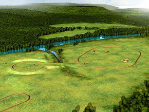
Farther upstream, just west of the village of Morrow, the new Little Miami High School marks the site of the Stubbs Earthworks, once one of southwest Ohio’s grandest geometric earthwork complexes, and one of the earliest to be destroyed. An irregular mound remains in the school’s circular driveway, covering the remains of a complex, multi-chambered building. In 1998, Dr. Frank Cowan and his team from the Cincinnati Museum Center discovered, about where the school’s grandstand is now, post molds from a giant, 271-foot diameter Woodhenge, the first large timber construction of its kind known from the Hopewell era. It coincided with a circle on an early 19thcentury plan of the earthworks, suggesting the idea that many earthworks may be have been built as markers or memorials to earlier timber constructions.
From Morrow, take back roads towards Fort Ancient [see Fort Ancient itinerary], or head south and east toward Hillsboro.
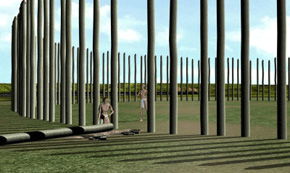
At its discovery in 1998, the Stubbs Woodhenge was the largest timber structure known to have been built in the Hopewell era.
 HILLSBORO AND VICINITY
Enroute from either Cincinnati or Fort Ancient to points east (The Paint Valley, Fort Hill, or Serpent Mound) almost all roads pass through Hillsboro. The very early Greek Revival Courthouse stands in the center of town; East Main Street (US 50) presents a beautiful array of historic houses. East of Hillsboro, watch for the sharply rising edge of the Appalachian Plateau, and the fundamental geological and ecological changes that accompany it. Many of ancient Ohio’s greatest earthwork monuments are clustered along this natural seam, where multiple resources and landscapes could be combined and celebrated.
 FORT SALEM EARTHWORKS
Between Cincinnati and Hillsboro, and with a few extra hours and a sense of adventure, consider searching out the Fort Salem Earthworks, two conjoined mounds together with a 450-foot circular ditched earthwork, recently purchased by the Archaeological Conservancy and restored. Its remote location bridges the two dominant Adena and Hopewell cultural regions – the Little Miami and Scioto valleys. The site overlooks a sharp bend in the river below, where turtles breed, suggesting the conjoined mound may represent a turtle. The address is 4206 Certier Road.
A double mound stands near the center of the well-preserved Fort Salem Earthworks, a few miles southwest of Hillsboro.